March 19, 2026
On December 4, 1676, one of the bloodiest battles in history
took place just north of Lund between the Swedish and Danish armies.
When darkness fell that evening, almost half of the participants had fallen.
Around 9,000 dead and dying remained on the battlefield.
For the 200th anniversary in 1876, an initiative was taken to
build a monument with the message of reconciliation between Denmark and Sweden,
not as a memorial to the Swedish victory.
It was inaugurated in 1883, built in concrete.
It was replaced in 1930 with a more durable copy in granite.
The monument is surrounded by a park, Monumentsparken,
approximately where they clashed on the afternoon of December 4, 1676,
between Kävlingevägen, the Norra ringen and the Södra stambanan.
I cycle there and park my bike along the path up towards the monument.
An inscription reads:
On December 4, 1676, people of the same tribe fought and bled here.
Reconciled descendants erected the memorial.
On the monument are a number of cannons. In the fall of 2019,
a number were stolen,
which were replaced in 2024 with new, less theft-prone copies.
To the north of the monument is a Bronze Age mound, Lerbäckshög.
I go up it, from the top you can see the monument now that
it's green.
I pick up the bike and cycle up to Norra Ringen, also
from here you can see the monument between the tree trunks this time of year.
Map
GPS: WGS84 decimal (longitud, latitud) 55.71940,13.18449

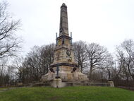 memorial in Monumentsparken to the Battle of Lund.
'In 1676 on December 4th, people of the same tribe fought and bled here.
Reconciled descendants erected the memorial.'
Erected in 1883.